
Canadian Forest Fire Danger Rating System (CFFRDS)
The Canadian Forest Fire Danger Rating System (CFFDRS) is Canada’s national framework for assessing wildfire potential. It provides both qualitative and numerical indicators to support decisions on resource deployment, public safety, and wildfire operations.
Two core subsystems form the foundation of the CFFDRS: the Fire Weather Index (FWI) System, which estimates fire danger based on current and forecasted weather, and the Fire Behavior Prediction (FBP) System, which models fire behavior based on fuel type and condition, weather, and terrain.
Fire danger refers to the likelihood of a fire starting and the potential difficulty of controlling it. Fire behavior, on the other hand, describes how an active fire will spread, how intensely it will burn, and how much vegetation it may consume. The CFFDRS combines inputs from weather, fuels, and topography to assess both.
These systems are widely used across Canada and internationally as operational tools for wildfire risk assessment and response planning.
Fire Weather Index (FWI) System
The Fire Weather Index (FWI) System is the primary tool used to assess fire danger within the CFFDRS. It produces six numeric ratings based solely on weather conditions: three fuel moisture codes and three fire behavior indices (Figure 1).

Figure 1. Structure of the Fire Weather Index (FWI) System, showing the relationship between fuel moisture codes (FFMC, DMC, DC) and fire behavior indices (ISI, BUI, FWI).
The fuel moisture codes—Fine Fuel Moisture Code (FFMC), Duff Moisture Code (DMC), and Drought Code (DC)—continuously track moisture trends in surface litter, shallow organic layers, and deep duff, respectively. Higher values indicate drier fuels and increased ease of ignition.
The fire behavior indices—Initial Spread Index (ISI), Buildup Index (BUI), and Fire Weather Index (FWI)—represent the potential rate of fire spread, the amount of fuel available to burn, and the expected fire intensity. Higher values reflect more severe fire danger conditions.
FWI values are traditionally calculated using daily noon weather observations (temperature, wind speed, relative humidity, and 24-hour precipitation), based on the assumption that fire danger peaks around 1600 local time. The resulting indices are intended to represent fire danger at that assumed peak period. The system does not account for fuel type or local topography.
To better capture evolving fire potential, an hourly version of the FWI System was developed (Rodell et al. 2024). This hourly FWI (HFWI) uses high-resolution weather forecasts to estimate how fire danger changes throughout the day, enabling more dynamic and time-sensitive assessments—especially during periods of increased fire activity outside the typical afternoon peak (Figure 2).
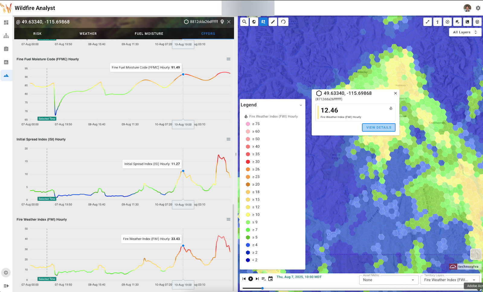
Figure 2. Example of the Hourly Fire Weather Index (HFWI), showing how fire danger estimates evolve throughout the day. Unlike the traditional FWI, which assumes a fixed peak in midafternoon, HFWI captures multiple or shifted peaks based on hourly forecasted conditions.