
Models Implemented in WFA
APPENDIX D. Models Implemented in WFA
This appendix provides a list of the analytical models that are implemented in Technosylva’s Wildfire Analyst product line.
The Wildfire Analyst™ Enterprise propagation core is comprised of a group of fire behavior libraries developed by Technosylva. These libraries are responsible for the fire simulation, weather data processing and the processing of the main outputs of WFA. The main models used in the implementation of Wildfire Analyst™ are shown in the table below.
Many of these models were originally published from research by the USFS Missoula Fire Sciences Laboratory. Technosylva has implemented, and enhanced these models, in addition to developing new models, to run in an operational scenario that requires real-time performance and visualization in desktop, web and mobile platforms. Most Technosylva custom developed models are supported by journal publications as part of our corporate R&D program.
Model | Model Reference | Notes |
Surface Fire Propagation | Rothermel 1972, Albini 1976 Kitral IntecChile | WFA uses the core Rothermel model for fire propagation, however, it can be configured for custom versions to support any empirical or semi-empirical fire model. This has been done for other countries, i.e. Chile, Canada, etc. |
Coupled Fire Atmospheric Propagation | Mandel, Beezley & Kochanski 2013 | WFA has integrated the Fire Atmospheric Coupled WRF-SFIRE model in collaboration with SJSU Fire Weather Lab in 2022 |
Surface Fuel Models | Rothermel 1972, Albini 1976, Scott & Burgan 2005 | WFA supports both accepted surface fuel models, i.e. 1972 thirteen fuel models, and the more recent and readily used 2005 forty fuel models. Custom fuels models can also be defined to meet specific landscape characteristics if desired. For example, Technosylva commonly delineates more classes for non-burnable fuels to support advanced urban encroachment algorithms requiring finer resolution data. |
Time Evolution | Technosylva (Monedero, Ramirez 2011) | Minimum Travel Time algorithm with 12 degrees of freedom, 4 of which are automatically selected. |
High Definition Wind | Forthoffer et al (2009) | High resolution wind model through obtained from the integration of the USFS WindNinja third party software. Note Technosylva is also the contractor for the USFS Fire Sciences Lab. for the on-going enhancement and customization of the WindNinja software. |
Wind Adjustment Factor | Andrews 2012 |
|
Fire Shape | Anderson 1982, Farsite (2004) |
|
Moisture Content | Rothermel (1983) |
|
Crown Fire | Scott & Reihnhardt 2011 | As used in Behave. 0-Surface Fire: Fire spreads through the surface fuels that may include litter, grass, shrubs, and dead twigs. Surface fuels are generally defined to be less than about 6 feet (1.8 meters) deep. 1-Passive Crown Fire (Torching): Fire spreads through the surface fuels, occasionally torching overstory trees. Spotting may increase the spread rate, but the overall spread rate may be the same as the surface fire spread rate. 2-Conditional Crown Fire: A fire cannot transition into a crown fire in this area, but active crown fire is possible if the fire transitions to the overstory outside the area and burns into the canopy. 3-Active Crown Fire: Fire spreads through the overstory tree canopy. 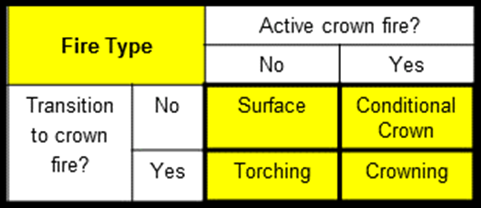
|
Firebreaks | Technosylva (Monedero, Ramirez 2011) | This custom model can utilize firebreaks width in landscape units and hence is not based on data the cell size. This is a significant enhancement over previous methods. |
Probabilistic Mode | Technosylva (Monedero, Ramirez 2013) | Inspired by the USFS Fire Sciences Lab FSPro software, Finney 2012. |
Adjustment Mode | Technosylva (Monedero, Ramirez 2011) | Allows for adjustment of ROS factors based on in-the-field fire observations. This allows the propagation model to continually adjust to match what occurs in the field resulting in more accurate simulation outputs. Described in Ramirez et al 2011, Cardil et al 2019. |
Reverse Mode | Technosylva (Monedero, et al 2015) | Ability to calculate the propagation mode backwards in time based on a final perimeter to show fire progression and ignition location. |
Evacuation / Exposure Mode | Cova (2005) Technosylva (Monedero, et al 2015) | Estimate fire arrival time from any point (i.e. asset) on the map. This is typically used to identify exposure sheds for key assets or values-at-risk, showing how long until a fire would reach those assets from any direction. |
MTT (Fire Paths) | Finney (2005), Flammap | Showing fire progression paths identifying the key travel routes of a fire. Based on Finney (2005) as first implemented in USFS Flammap, with enhancements on performance and real-time calculations within Wildfire Analyst. |
Campbell Analysis | Campbell (2009) Technosylva (Monedero, et al 2012) | Based on Campbell's concept of Alignment of Forces implemented as a standard output in Wildfire Analyst. |
Safe Separation Distance | Butler 2014 |
|
Ignition probability | Schroeder 1969 | Probability of Ignition is estimated from:
 For more information click here. |
Urban Encroachment | Technosylva 2016 | Includes several variations of urban encroachment algorithms developed internally to facilitate spread of fires into non-burnable urban fuels. This incorporates a distance based friction model that can be parameterized by the user. Based on research publications by NIST. |
Spotting | Technosylva 2019 | Spotting is implemented as a random process of new ignitions ahead the main fire front. The model uses the maximum spotting distance from wind-driven surface fires developed by (Albini 1983a; Albini 1983b; Chase 1984), together with some heuristic parameters.
|