
What is WFA?
Wildfire Analyst is fire behavior analysis software that provides a rich suite of capabilities and multiple simulation modes to derive wildfire risk outputs. The software has been available as a Windows Desktop software package for 10+ years, focused on providing detailed fire behavior modeling capabilities to FBANs, LTANs, and fire planners (Wildfire Analyst™). The software is characterized by its rich functionality, seamless data integration, and very fast processing speed for simulations (i.e. less than a minute for most simulations). The software version is widely used by federal and state agencies across the Nation, and has been actively used on the Thomas, Tubbs, Woolsey, and Mendocino Complex Fires over the past few fire seasons.
With increasing demand for large scale wildfire risk forecasting and analysis by electric utility companies, Technosylva developed a cloud-based High Performance Computing (HPC) version of Wildfire Analyst, called Wildfire Analyst (WFA). Over the past five years, Technosylva has advanced WFA to develop a cloud-based subscription service that is scalable to support hundreds of millions of simulations daily over large geographic areas.
When combined with advanced weather forecasting systems, WFA can generate highly accurate wildfire risk outputs based on the spread simulations. In addition, the WFA solution incorporates automatic impact analysis by combining the spread predictions with California-wide datasets for population and structures (buildings). Risk metrics are automatically calculated for each simulation for 1) number of buildings impacted, 2) population impacted, and 3) acres burned. Other values-at-risk can also be integrated easily into the impact analysis.
Wildfire Analyst Software Core
This software is the core fire behavior analyst engine providing API access for fire spread prediction requests. It is based on the robust Wildfire Analyst Desktop fire behavior models that provide a full suite of modeling capabilities based on proven and published fire science. Appendix D provides a list of the fire science models currently implemented in Wildfire Analyst, although this changes frequently as we continue to refine and enhance the models based on scientific and R&D achievements.
The Wildfire Analyst core provides all the fire behavior analysis and fire spread prediction capabilities through a standard API.
The Wildfire Analyst core supports a parallel batch processing approach that provides extremely fast performance for completing prediction requests, i.e. 20-30 seconds.
The Wildfire Analyst core is installed on both the HPC and Simulation servers to satisfy the risk forecasting and on-demand requests individually.
FireRisk Desktop Application
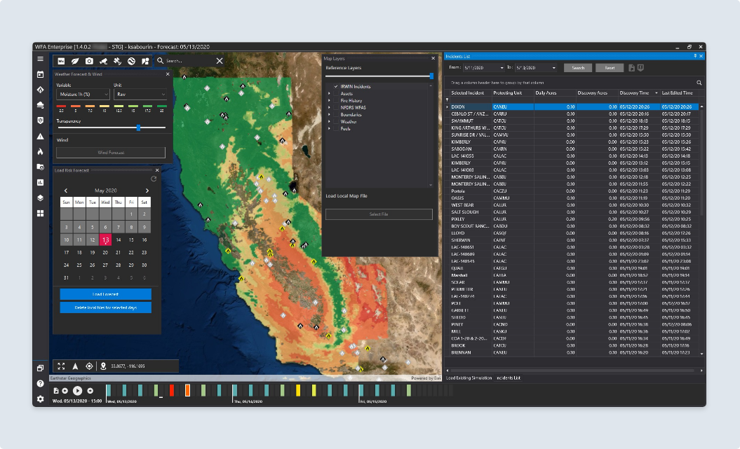
WFA FireRisk software interface.
FireRisk is the primary client-side desktop application to access the weather forecast and wildfire risk forecast data. It provides a 3-D map viewing environment supplemented with temporal data functionality to facilitate efficient visualization of the forecast data.
Tools are provided to download and load a daily risk forecast for any time period. Forecasts are derived daily using a three day horizon (typically 72 hours).
Seamless integration with IRWIN provides near real-time access to California incident data from CAL FIRE, USFS, LA County and other agencies providing data to IRWIN. Data is currently updated every minute.
The above figure presents an example of the FireRisk software interface showing 1 hour Fuel Moisture for 05/13/2019 at 3:00 pm. CAL FIRE incidents are also shown in addition to the forecast selection tool.
FireSim Desktop Application
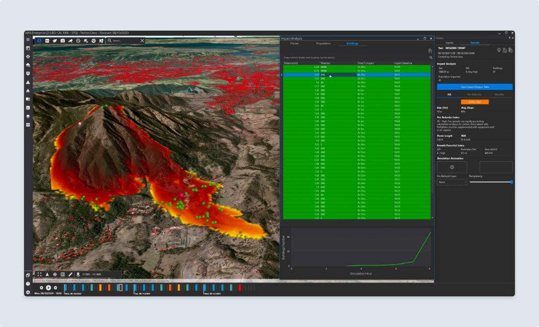
WFA FireSim software interface.
FireSim is the primary client-side desktop application used to conduct on-demand fire spread prediction. The application operates within the FireRisk 4-D environment as a separate user interface leveraging the availability of the rich weather forecast and weather station data integration.
It provides capabilities to request fire spread predictions for any time period in the currently loaded 72-hour weather forecast. This affords capabilities to simulate fires based on predicted weather scenarios in advance of incidents occurring. Using the FireRisk risk forecast provides insights to those areas that pose significant impacts should a fire occur. Using FireSim, the user can simulate fires to determine possible impacts.
Simulations are typically completed in 20-30 seconds with impact analysis.
Full impact analysis is included with each simulation identifying the number of buildings, population, hospitals, schools and critical facilities impacted by each prediction. Impact layers representing important values-at-risk can be easily integrated into the impact analysis if desired. Outputs can be fully viewed in the FireRisk/FireSim environment, or if desired exported to Google Earth or other formats for viewing.
The FireSim tool is also seamlessly integrated with IRWIN incidents allowing the user to select an existing incident and simulate the fire using the incident ignition coordinates.
Urban encroachment capabilities are provided, allowing for user calibration, to estimate possible spread and impacts into urban areas. This is useful for fire specialists with a good understanding of local fuels and expected fire behavior. They can tailor the urban encroachment to reflect this local knowledge and fire experience.
The above figure presents an example of the FireSim software interface showing a 6-hour prediction with buildings impacted. The 3-D map shows the time of arrival of the fire, color coded by burning front. Tools are provided to view the map by time step if desired, or to animate the map. The green points represent structure locations. The impact analysis summary panel shows a list of buildings impacted by the fire, sorted by 'time since ignition'. Information is calculated for each impacted building showing:
1) distance from ignition point
2) direction from ignition point
3) time to impact from Ignition
4) specific time building will be impacted.
A chart shows the hourly and cumulative number of buildings impacted. Specific costs of impacts can also be calculated by customizing loss factors and damage costs calculations if desired.
The Simulation Results panel (on left) summarizes the size and impacts of the fire, including an Initial Attack Assessment metric. This metric uses growth characteristics (behavior and growth indices) to estimate the likelihood that the wildfire will be contained. Suppression effectiveness of resources is not incorporated, although it could be added if desired. The intent of this metric is to provide the fire professional a quick, quantifiable measure of suppression difficulty to aid in determining the seriousness of the fire.
WFA Mobile Application
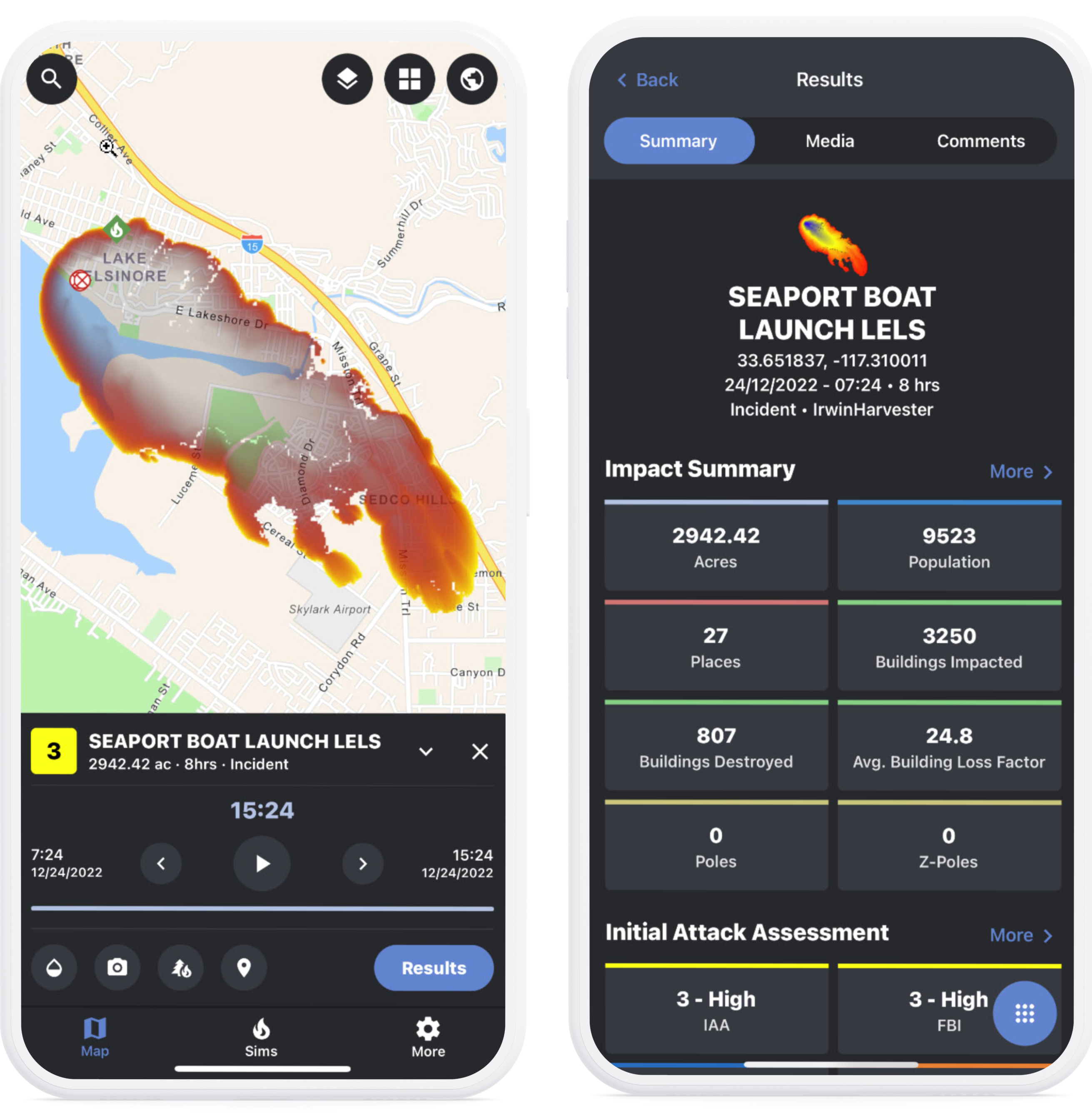
To supplement the FireSim desktop application, a Native mobile application (iOS or Android) is provided to facilitate simulation requests while in-the-field. The mobile app allows the user to request a simulation for the current weather forecast (72 hours). The forecast is updated daily.
WiFi or cellular connectivity is required to submit a prediction request.
Predictions typically take 10-20 seconds before the results are automatically downloaded to the local device. Results are stored locally.
Each prediction includes full impact analysis and provides tools to review the prediction extent on a map (in 10 min intervals), review the impact results with an Initial Attack Assessment metric, and retrieve previous simulations from the cloud-server on request.
All simulations are synced with the centralized server and fully available between FireSim desktop and FireSim mobile.